|
The Land of Urr in the Stewartry of Kirkcudbrightshire. There are a
variety of sources given for the Orr name, which is
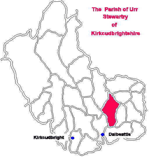
essentially of The Parish
of Urr is quite long being some fourteen miles in the
North - South direction and between one and six miles
wide. Overall the area
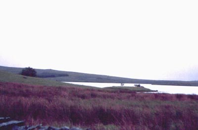
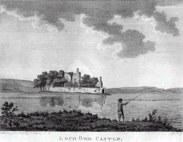
Certainly the district and parish as such was referred to as Orr [sic] as long ago as 1684 in "A Large description of Galloway " by Rev Andrew Symson. This was a response to the request for information for a new map by Sir Robert Sibbald, following his securing a patent from King Charles II as His Majesty`s Geographer for Scotland. Symson wrote: The Bishop of Edinburgh is patron hereof, as depending on New Abbey. The kirk of Orr is twelve miles distant from the town of Kirkcudburgh , and twelve miles distant from the town of Dumfreise. The parish of Orr is bounded eastwardly with the parish of Kirkgunnion; on the southeast with the parish of Cowend; and on the south and south west with the parishes of Bootle and Corsemichael, from both which parishes it is separated by the river of Orr; on the north west it is bounded with the parish of Kirkpatrick Durham; on the north by the parish of Irongray; and on the north east, it is bounded with the parish of Lochruiton. He says of the river Orr : Orr hath its rise from Loch Urr or Loch Orr, which loch is situated betwixt the parish of Balmaclellan, on the west side, and the parishes of Glencairn and Dunscore, on the east side. In this loch , there is an old ruinous castle, with planting of sauch or willow trees for the most part about it. where many wild geese and other water fowles breed; to this place there is an entrie, from Dunscore side, by a causey which is covered with water knee deep. This loch is replenished with pikes; many salmon are also found there at spawning time.......... This river is foordable in many places; being foordable also at Kipp Ford when the tide obstructs not, although, at spring tides the sea water flows up as far a Dub O`Hass. However, if the water be at any time great, there is a stone bridge over it, call`d the Bridge of Orr, which joynes the parishes of Kirkpatrick Durham and Corsemichael together. The Statistical Account
for Scotland 1799 ( which is on line at
http://edina.ac.uk/StatAcc/Index.shtml ) has an
interesting footnote about the Parish of Urr,
at Kirkcudbright, bottom of pages 62 and 63. This
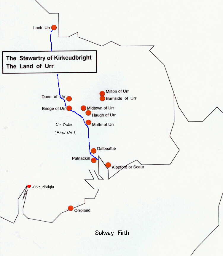
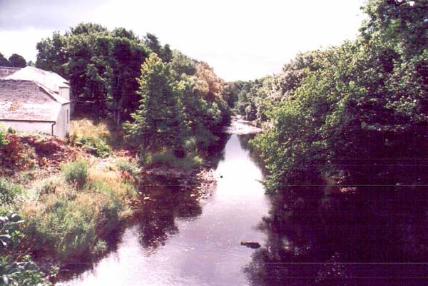
The river
flows twenty six miles from its source in rather desolate
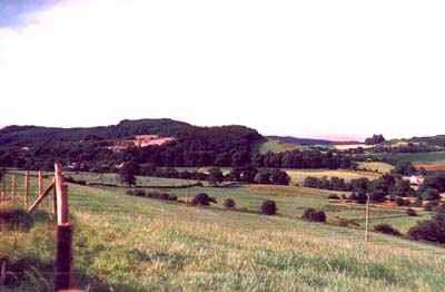
There is
the earthwork called the Motte of Urr nearby and several
other Urr features - Urr Water which flows to the sea from
Loch Urr and in the 11th and 12th century passed through
the port of Hur which was between Dalbeattie and the old
port of Dub O` Hass. The Milton of Urr was a village on
the 17th century old military road though there are
suggestions of medieval and Roman occupations as far back
as the 2nd and 3rd centuries. After about 1800 it The terrain
is of rolling hills, none of which are especially high,
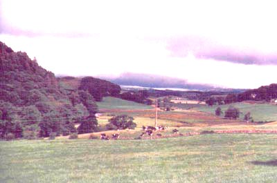
but enough to give splendid views to the hill walker. The
river valley has good soil and rich pastures where sheep
and cattle, including the long
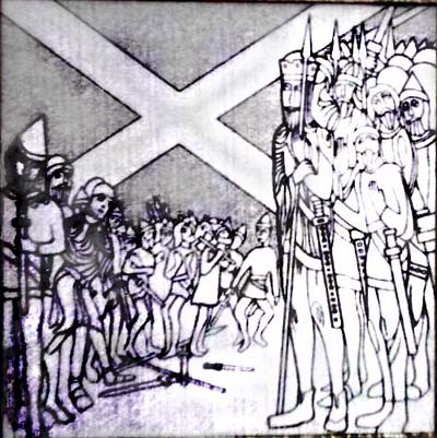
It is easy to see that this land of forests and mosses was once home to now extinct species of wild boar, wolf, bear, deer and the urus, a kind of ox. It is possible that the Urr / Orr name stemmed from the Latin and also the Norse word urus for wild ox and boar. The spelling has varied from Vr, Ure, Hurr, Whur and Wur but the sound of it remains reasonably constant. In the primitive language of the Basques, a race said to be older than the Celts, Urr signifies water, or close to water. So it is reasonable to believe that Urr is `from the river ` and applies to the Celts who lived on its banks. The early populace The earliest peoples of whom there is definite information were Celts, although there is conjecture that there may have been a small dark haired peoples who have disappeared. The Celts were hunters and had the name Selgovae ( derived from the Gaelic for hunter ) and also known as Picts or painted people from the tattoos with which they adorned themselves. Their original dwellings would have been the caves and, in time, shelters constructed with stakes in the ground and covered by leafy branches. These progressed to wattle and daub - sticks and mud, and eventually more substantial buildings of hewn timbers, with gaps filled by clay and roofed with straw, ferns and turf. The Rev David Frew wrote a definitive work about the Parish in 1909 and has this to say about the early people of Urr around the 12th century. A novel, although quite common feature in the region are the houses built on islands, usually man made by driving timbers into the bottom of a lake and backfilling with branches and stones to give a foundation on which to build a house. These `crannogs` have an Irish origin and are found mainly in Ireland and Scotland with a recent discovery in Wales. They had hidden, secret, paths to them which would zig zag beneath the water so only those in the know could safely access them. Excavations in the Milton Loch in 1953 exposed a large farmhouse on a circular timber platform and a wooden gangway. Elsewhere the land dwellers have left many traces of their passing with hill forts, hut circles and burial cairns. A Roman geographer, Claudius Ptolemaeus of the second century placed a large settlement of Caer - bantorigum, one of the four main towns of the Selgovae, in the vicinity of the Motte of Urr. The Roman legions were active in the area in 79 AD and it appears that for three hundred years they occupied the valley of the Urr and probably used the site of the Motte as an encampment. Little is known of the inhabitants after the Romans left Britain in 407 AD and we must assume that there continued to be trade, movement and inter marriage with the Irish Picts just 21 miles across the sea from the Mull of Kintyre. About the seventh century there was an alliance with Angles from Northumbria and the Kings of Bernicia ( the Lothians and Northumbria ) who probably ruled the area although local government remained in the hands of local chieftains. It is this delegated rule that is thought to have given rise to the name of Galloway, being called by other Gaels Gallgaidhel or Gallwyddel - stranger Gaels. The Norsemen and the Normans. The Angles
gave way to the Norsemen in the ninth century and for the
It is interesting that the name Orre should turn up early on the East coast of England where Norman knights from William the Conqueror`s time had lands. A possible Norman link appears in the Lincolnshire Assize Roll of 1298 with reference to a Roger Orre in 1202.These same Normans were in Northumberland and southern Scotland by the 1100s so there is a tantalising possibliity of a connection here. David I `s reign was one of relative peace and consolidation of the emerging Scotland into one kingdom and the introduction of the feudal system of land tenure. There was a problem when Donald MacHeth claimed the throne on David`s death in 1153 , and for three years had the assistance of Somerled, King of the Isles. However, Somerled withdrew his support and continued to make a nuisance of himself elsewhere until slain at Renfrew in 1164. In the meantime Fergus, Lord of Galloway seized his chance to try and break away but was tamed in 1160. Subsequent attempts were made by a succession of Lords of Galloway , Uchtred, Gilbert, Roland and Alan to get rid of the Scottish allegiance but they also lost their struggle. Although subjugated militarily there was a stubborn resistance to change in the south west where the Picts and their descendants maintained a sturdy independence, and continued to speak Gaelic until after the Union of the Crowns in 1603. In the thirteenth century the lordship of Galloway was divided up between four members of the ruling famiy, including John Baliol and Alexander Comyn. Under these leaders the men of Galloway were the opponents of King Robert the Bruce whose brother Edward finally subdued the area in 1308. In 1369 the eastern part of the area was given to Archibald Douglas, the Grim, who built the stronghold of Threave castle. The evidence The earliest records of Urr occur in the charters of Holm Cultran, an abbey in Cumberland, which owned lands in the parish of Kirkgunzeon adjacent to Urr. In these a Hugo of Hurr and his son Thomas appear as witnesses to charters. Records also show the lordship of Urr in the possession of Walter de Berkeley (died ca 1194) who was Chamberlain to King William I. From him it passed by marriage to the Balliol family who occupied Buittle Castle. Two witnesses to a Balliol of Urr Charter of 1262 - Adam Clerk and Hugo Sprot, were described as burgesses of Urr. Hughe de Urre del Counte de Dumfres appears In the Ragmans Rolls, declaring allegiance to Edward I in 1269. His lands were later given to Henry de Percy who had been appointed Keeper of Galloway. George Black in his ` Surnames of Scotland ` tells us of Hugh de Hur who was a member of an assize court in the Marches of Grange of Kircwynni and the land of Culven in 1289. Hugo of Hurr , possibly the same family, was witness to a charter by the Kirkconnel family in Kirkgunzeon. And Hugh de Ur was a juror on an enquiry as to the priveleges claimed by Robert de Brus, Earl of Carrick, in 1304. What these references indicate is that an area of land called Urr had already been defined and made a barony by the mid 1200s. A map by Chatelain & Guerdeville dated 1720 , in the Museum of Scotland , shows the village of Orr just south of Dumfries. A search of the 1841, 1851 and 1881 Censuses, however, shows few Orrs in the area; in 1881 there was only one family of Urr / Orr then in Kirkcudbright, being a dwelling at Auldon Bank, Troqueer. It is especially interesting as the two sons of the house, both born in Maxwelltown, are named differently - James M. Orr aged 5 yrs and his brother Thomas Alexander Urr aged 3 years, demonstrating how easily the change of name occurs. A time of Turmoil The evidence is of turmoil in the area which was subject to an ongoing demand by the local lords for feudal service by the men in their respective armies. Towns began to emerge in the reign of William I (1185 - 1200) such as Dumfries in 1186 and Ayr in 1197. These were intended as secure bases from which the sheriffs helped to pacify the region; and as defences against the lawless bands. They also became the centres from which trade developed in surplus agricultural produce being influenced by the success of the Cistercian monks who had developed sheep farming and manufacture of associated goods. It is sometimes forgotten that feudal military service took the men from the land and it is more than coincidence that famine was common and often followed by pestilence and plague. Thus the turmoil , famine, plague, and constant demands for military service would have been cause enough for the migration of people who had been held in thrall by the local lords for so long. It has to be conjecture that the ancient peoples of Urr migrated northwards to Ayrshire and Renfrewshire. But it is relevant that the valleys run from the south east to the north west and this would have influenced trading routes and migration to areas where Orrs are to be found in number in later centuries. Dalry is about 20 miles and Dalmellington about 35 miles north west of Dalbeattie; and the nearby Nithsdale route runs from Dumfries to Kilmarnock , Lanarkshire, and to the River Clyde and Glasgow. As Prince of Cumbria David ( King David I 1124 - 1153) had caused an inquisition to be made of the lands and buildings that had belonged to the ancient church. Acting on that information David created the bishopric of Glasgow in 1121. This new diocese stretched from the river Clyde to the Solway and from the Lothians to the river Urr in Kirkcudbrightshire. The consequence was a rapid growth of feudalism with land becoming the basis of power. The feudal system itself made for a closer control by the King who gave land to many foreign Lords and Sheriffs, including Crusaders, Knights of St John , Knights Templar and other Norman knights. At the end of the chain of tenancies was the common man with winners and losers over the tenancies of the smallest acreages. In this respect a growing source of land was the church which received great support from David. In his reign the Culdee churches of the Celts at St Andrews and Lochleven disappeared and new monasteries arose and existing ones were strengthened. Conclusion. If the Orrs came from the Parish of Urr, and I think they probably did, the fact is that not many Orrs or Urrs are to be found there today. Something cataclysmic happened in Urr, possibly during a revolt by one of the Lords of Galloway, to destroy a substantial settlement like the Motte of Urr. Was it war or plague ? - we may never know. We do know that the coming of the Norman knights to the south west of Scotland saw the replacement of wooden forts and motte and bailey castles, with fine stone castle such as at nearby Buittle, built on a hillock on the western edge of the River Urr. This was the favourite home of John Baliol , erstwhile King of Scotland, and his mother Dervorgilla. The death of the young Maid of Norway, grandchild of Alexander III , meant that the succession to the Scottish throne was in disarray. Edward I of England seized the opportunity to impose himself as "Lord Paramount" and on 11 June 1291 the four regents of Scotland handed the throne and the kingdom of Scotland into Edward`s hands. There followed the proceedings to determine who should be King of Scotland, which Edward finally decided on 17 November 1292, should go to John Baliol A feature of affairs at this time was the transfer of the castles or fortresses of Dumfries and Galloway first to Walter de Curry in 1291; then to Robert Siward in 1292. In April 1296 John Baliol resiled from his vassalage and declared for a free kingdom which led to an immediate military subjugation by Edward`s army. About this time Edward, perhaps in a fit of pique, is said to have restored all the lands of Galloway to Thomas, illegitimate son of Alan, the last Lord of Galloway. In September 1296 the castles of Ayr, Wigton, Cruggleton and Botol (Buittle) were committed to the keeping of Henry de Percy when he was appointed Keeper of Galloway. He also received a portion of land in Galloway as, in the later reign of Robert I, land consisting of half of the barony of Urr, was granted to Thomas Randolph, Earl of Morray, when it was forfeited by Percy. It was also in this period that William Wallace began his fight for freedom and Edward`s army retaliated with great force burning and looting all places of resistance. This constant unrest and changing ownership of land would have changed the status for the motte and its occupants. More so, as the people in a feudal society were part and parcel of the land on which they lived, they would have had several changes of loyalties forced upon them each time a new new master came along. It is little wonder that there was a drift of the population away from the area, leaving the motte for lesser nobles or gentry before adoption by farmers. Mottes with earthen slopes and wooden palisades did not serve any real defensive purpose from about the fifteenth century. Another factor in this period was the emergence of the church as a major land holder. At the end of King David I`s reign ( 1153) there were nine dioceses, not including Galloway ( which remained under the Archbishop of York`s jurisdiction). This expansion meant that the vast wealth and lands of the mediaeval church became a factor in the transformation of a backward country. Perhaps this was a factor in the migration of the Urrs / Orrs to the church lands of Lochwinnoch where they were tenants of the Abbey of Paisley ca 1300. Hughe de Urre ( who lost his lands to Henry de Percy ) would have had the motive; the bishopric of Glasgow, which David had created, would be known to him; he would have had the contacts at Court and probably the money to be able to make such a move. Indeed, he may have been compensated with church land in Lochwinnoch when the barony of Urr was given to others. Conjecture I know, but for now, this is my favourite hypothesis. If you find anything different please get in touch. |